Last Updated on March 6, 2026 by Devour Tours | Published: September 24, 2020
Spain is a country of contrast, with bustling cities like Madrid beautifully complemented by breathtaking natural landscapes not too far away.
For those of us who live in said big cities, sometimes it’s nice to get away and spend some time out in nature.
Here, we’ve rounded up our favorite spots for hiking in Spain throughout the country. No matter what your skill level is, where in Spain you’re based, or how much time you have, there’s a hiking route here that’s perfect for you!
Andalusia
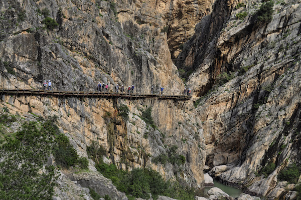
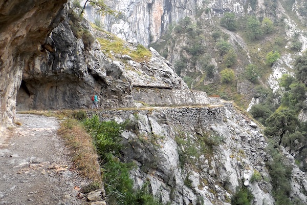
1. Caminito del Rey (Malaga)
Difficulty: Intermediate | Length: 7.7 kilometers (4.7 miles)
Once considered the most dangerous footpath in the world, the legendary Caminito del Rey in Malaga province now has plenty of safety installations. Still, it’s no less impressive.
Its famous gravity-defying wooden walkways clinging to the sides of the mountains and spanning the Gaitanes Gorge aren’t for the faint of heart (or the easily prone to vertigo). But the views they offer, and sense of accomplishment you get upon finishing the hike, are well worth it.
Keep in mind that due to the popularity of this trail, you’ll need to book your visit in advance, which can easily be done through their website.
How to get there from Malaga
By car: Take the A-357 highway west and then north for about 46 kilometers total, then switch to the MA-5403. Continue until you reach the town of El Chorro, where you can park at the train station and take a shuttle bus up to the starting point of the hike. The end of the hike is very close to the town, so you can easily get back to your car from there.
Additionally, you can drive up to El Kiosko restaurant, which is very close to the starting point of the Caminito del Rey. Parking is available near the restaurant, but it’s quite limited, so taking the shuttle from El Chorro will likely save you some trouble.
By public transport: There are a few trains a day that connect Malaga and El Chorro. Once you arrive in the smaller town, you can take the shuttle bus up to the starting point of the hike.
2. Bailón River Trail (Cordoba)
Difficulty: Intermediate | Length: 12 kilometers (7.4 miles)
A UNESCO-recognized slice of natural beauty in the heart of Andalusia, the Sierras Subbéticas offer some of the best hiking in Spain.
One standout is Cordoba province’s Bailón River trail, which starts at a gorgeous 13th-century sanctuary and ends in the picturesque town of Zuheros, home of some of Andalusia’s best cheese. (Need we say more?)
As you may have guessed, the route follows alongside the Bailón River. It gives you a look at some of Andalusia’s most impressive natural landscapes: waterfalls, mountains, lush greenery, and the awe-inspiring canyon forged by the river itself.
How to get there from Córdoba
By car: Take the A-45 highway south towards Malaga for about 68 kilometers and switch to the A-339 at Lucena, heading east. After about 7 kilometers, turn left onto CP-115, then follow until it ends at Santuario de Nuestra Señora de la Sierra, where you’ll find some parking before the trail starts. Keep in mind that you’ll need to take a taxi from Zuheros back to the sanctuary when you finish your hike (expect to pay around €12–15).
By public transport: Take a bus from the Cordoba bus station to the town of Cabra. From there, you can take a cab up to the sanctuary and the starting point of the trail. You can catch the bus back to Cordoba from Zuheros at the end of the route.
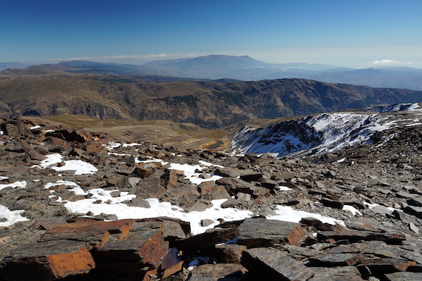
3. Mulhacén (Granada)
Difficulty: Moderate | Length: 15 kilometers (9.6 miles) one way
The highest mountain outside the Alps in western Europe, Mulhacén seems intimidating—and on many trails, it is. But approaching the summit from the southern face of the mountain, starting at the Mirador de Trevélez lookout point in the Alpujarras, is surprisingly easy, with no special mountain gear required.
Keep in mind that due to the high altitude, it’s best to complete this hike in the warmer months to avoid snow and ice. However, the nature in this part of Granada is absolutely beautiful, with wide-open landscapes and gentle local wildlife grazing peacefully in the nearby fields.
How to get there from Granada
By car: Follow the A-44 out of town, switching to the A-348 and A-4132 to A-4129 until you arrive in the town of Capileira. From here, a local bus takes you up to Mirador de Trevélez, where you can start the hike (normal cars are not allowed on the tight mountain road).
By public transport: Spain’s national bus company, Alsa, offers a few different buses every day connecting Granada and Capileira.
Asturias
4. Cares Gorge Trail (Picos de Europa)
Difficulty: Easy | Length: 12 kilometers (7.4 miles) one way
To say that the Picos de Europa are breathtaking would be an understatement.
The range is home to some of the best hikes in Spain, but many of them are quite long. The Cares Gorge Trail is one of the few that can be completed in less than a day, with plenty of time left over to enjoy the region’s famous cheese (you’re right in the heart of Cabrales country).
The route starts near the Asturian town of Poncebos and ends in Caín in the neighboring province of León. Following the Cares River, much of the path has actually been carved into the surrounding limestone rock formations themselves. Hiking amid the towering Picos is truly a humbling experience, and one you won’t soon forget.
Note: Many hikers opt to do this as a round-trip route, stopping in Caín for lunch before heading back uphill for the return trip. If you’d rather just go one way, you can usually find taxis in Caín that will take you on to your next destination.
How to get there
By car: You can access the starting point of the path from the AS-114 Cangas de Onis-Arenas de Cabrales (Las Arenas) road. When you arrive in Arenas de Cabrales, take the AS-264 to Poncebos.
By public transport: Buses to Poncebos are few and far between. If you don’t have your own vehicle, your best bet is to travel to Oviedo or Santander and take a cab from there.
Basque Country
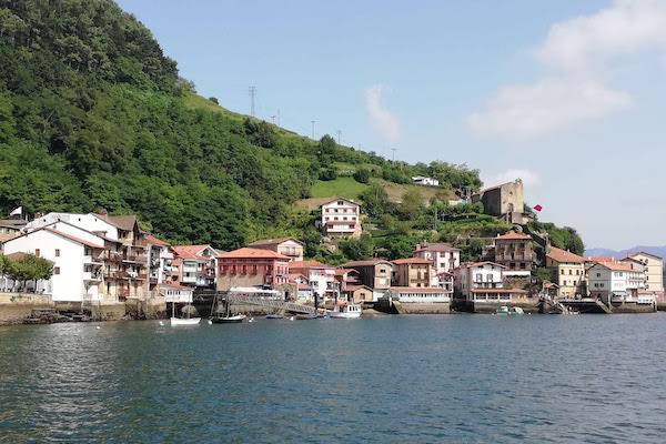
5. San Sebastian—Pasajes coastal path
Difficulty: Easy | Length: 7 kilometers (4.3 miles) one way
The fishing towns of Pasajes de San Juan and Pasajes de San Pedro make an idyllic day trip destination from San Sebastian. And the best way to get there from the city is by hiking!
The beautiful coastal path connecting San Sebastian and Pasajes starts in the Gros neighborhood and winds along the coastline through the forest cover of the lush Mount Ulía. It’s a relatively easy walk (the first few minutes are actually the most difficult), and you’ll be rewarded with gorgeous views of the rugged green coastline as you arrive to the end.
Fun fact: this path actually forms part of the famous Camino de Santiago pilgrimage route. Don’t be surprised if you run into a few pilgrims bound for Santiago de Compostela along the way!
How to get there
The starting point of the hike is right within San Sebastian proper. Start at the Larramendi gas station at the northern end of Avenida Navarra near the beach, and turn onto Calle Zemoria. Heading northeast, stay on Calle Zemoria. Soon, the road will give way to a staircase, which is the starting point of the climb.
If you don’t want to hike back to San Sebastian from Pasajes, there are regular buses that run between the two.
6. Ordizia—Segura (Idiazabal Cheese Trail)
Difficulty: Intermediate | Length: 13 kilometers (8 miles)
Yes, you read that right. One of the best hikes in Spain is a cheese lover’s dream come true.
The full Idiazabal Cheese Trail is a nearly 100-kilometer circular route that’s divided up into six stages. Completing the full trail takes about a week, so if you’re short on time, the final stage, between the towns of Ordizia and Segura, is perfect for a one-day excursion.
This route passes right through the town of Idiazabal itself, which lends its name to the region’s famous sheep’s milk cheese. If you have time for a break, you can check out the monument to local shepherds—who play an important role in bringing Idiazabal cheese to life—and the Tasting and Interpretation Center before continuing on to Segura.
How to get there from San Sebastian
By car: The town of Ordizia is less than 40 minutes’ drive south from San Sebastian along the A-1 highway. Once you arrive in Segura, you can take a bus back to Ordizia to get to your car.
By public transport: A handful of Renfe media distancia and Regional Express trains depart San Sebastian for Ordizia every day. At the end of the hike, you can catch a bus back to San Sebastian in Segura. Another option is to take a bus to nearby Beasain and get the train from there.
Catalonia
7. Santa Pau—Santa Margarida Volcano loop (Pyrenees)
Difficulty: Intermediate | Length: 11 kilometers (6.8 miles)
Forming a breathtaking natural border with France and Andorra, the Pyrenees also provide some of the best spots for hiking in Spain. The Santa Margarida Volcano loop is one of the most fascinating paths in this part of the country.
This route takes you right into the crater of the now-extinct Santa Margarida volcano, where you’ll find a small Romanesque chapel. You’ll also walk through the famous Fageda d’en Jordà, a beech forest growing right over top of an old lava flow.
How to get there from Barcelona
By car: Take the C-33 to the C-17, change, and follow the C-17 for almost 50 kilometers to exit 69. Get on the C-37, then change to the C-152, and from there to Avenida Sant Jordi. Turn onto Carretera de Santa Pau/GI-524 and follow it to the La Fageda d’en Jordà parking area just past the town of Can Blanc. After parking, you can easily access the trail on foot.
By public transport: The bus company Teisa runs several journeys per day between Barcelona and the town of Olot. From Olot, you can take a cab to the starting point of the route (just past the La Fageda parking lot) and be there in less than 10 minutes.
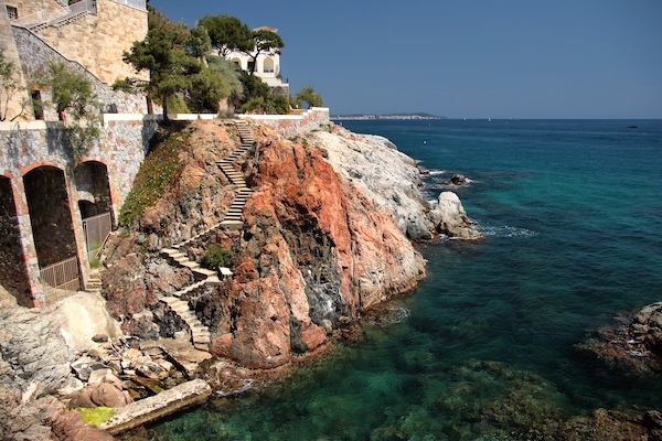
8. Begur—Calella de Palafrugell (Cami de Ronda, Costa Brava)
Difficulty: Intermediate | Length: 11 kilometers (6.8 miles)
Hiking the entire Costa Brava is the ultimate bucket list item. But for those of us who don’t have that kind of time, this stretch of the Cami de Ronda between the towns of Begur and Calella de Palafrugell does the trick.
This picturesque route takes you through the gorgeous fishing villages of Tamariu and Llafranc, with plenty of breathtaking natural beauty along the way. Be sure to give yourself plenty of time to take pictures and maybe even cool off with a quick dip in the hidden coves—this is the kind of route that is meant to be savored.
How to get there from Barcelona
By car: Take the C-33, AP-7 and C-35 to C-31. In Regencós, turn right at the roundabout to get on the GI-653 and continue east to Begur. Walk south along the GIP-6531 road until you see signs indicating the start of the route. When you arrive in Calella, you can find relatively inexpensive taxis back to Begur.
By public transport: There are several buses per day running between Barcelona’s Estació del Nord and Begur. When you finish the hike in Calella, you can take a local bus to the nearby town of Palafrugell and head back to Barcelona from there.
Community of Madrid
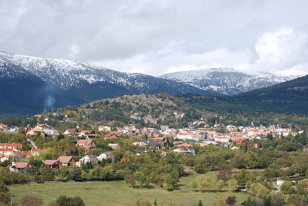
9. Cercedilla—Puerto de la Fuenfría
Difficulty: Easy | Length: 12 kilometers (8 miles)
Believe it or not, bustling Madrid is just a hop, skip and a jump away from some of the best hiking in Spain. The quaint mountain town of Cercedilla, a popular day trip from Madrid, makes for a great starting point to explore nearby nature.
There are a number of hiking trails around Cercedilla, but one great option is the Puerto de la Fuenfría trail (the orange trail if you’re following the marked signposts or a local map). Given the fact that much of the route is under the cover of the peaceful forest, this is one of the best hikes in Spain to check out in the summer.
This circular route is fairly easy. However, be sure to give yourself plenty of time to stop and enjoy the gorgeous surroundings. One standout it the Mirador Vicente Alexandre, which offers stunning views of the surrounding natural beauty.
How to get there from Madrid
By car: Take the A-6 north out of the city. Switch to the M-601 at Exit 39 in Collado Villalba. Once in Cercedilla, you can park at the Casa Cirilo restaurant near the trailhead.
By public transport: The C2 line of the Cercanías commuter train connects Madrid and Cercedilla.
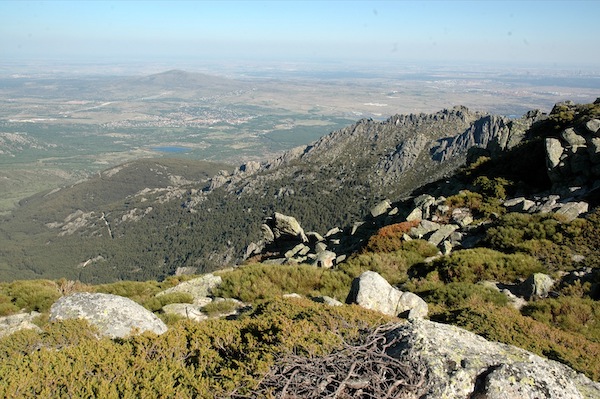
10. Las Torres de La Pedriza (Manzanares el Real)
Difficulty: Intermediate-high | Length: 15.5 kilometers (9.6 miles)
As one of the most unique hikes in Spain, the La Pedriza area in the Sierra de Guadarrama National Park offers dramatic rock formations and craggy, mountainous landscapes. Many of the hiking paths in this area are quite difficult. For an option that’s challenging without being too risky for less experienced hikers, check out the Las Torres de la Pedriza circular route.
An especially fascinating route for geology lovers, this route offers a nice mix of unique natural formations, challenging ascents and awe-inspiring mountain views. It’s on the longer side compared to other one-day hikes in Spain, so come prepared with proper footwear, plenty of water, and something to eat along the way.
How to get there from Madrid
By car: Take the M-30 out of the city and switch to the M-40 heading northeast. Take exit 57 to merge onto M-607 and from there, exit 35 for M-609. After almost 3 kilometers, take the ramp and follow the signs for M-608/Manzanares El Real. Follow the M-608 through the town of Manzanares and park in the La Pedriza lot near the visitors center just outside the western part of the village.
By public transport: Bus line 724 from Plaza de Castilla has stops in Manzanares El Real, and you can access the trailhead from there.